Footpaths In Marldon
Footpath – 


Bridleway – 
Unclassified Road – 


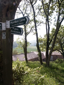
Marldon Lane is a public right of way (Unclassified Road 5) which runs between Aptor Farm (adjacent Higher Orchard Cottage) and Smallwell Lane (at a parish boundary stone). The route can be identified by a signpost at either end and is roughly 350M long. The route is relatively level but there is a gentle slope down to where the parish boundary stone is located. The surface consists of bed rock just below a thin layer of earth and there are some fine views from the lane out towards Berry Pomeroy.
