MARLDON PARISH MAP
The idea of a Parish Map for Marldon was conceived by the Parish Council (as a Millennium project) a few years before the Millennium, and finally got off the ground by
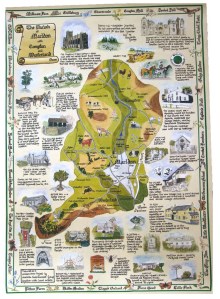
the formation of a Marldon Parish Map Group in 1998. However, many years before the launch of our Map, the conservation charity Common Ground in 1987 launched its national Parish Map Project, and since then hundreds of parish maps have been made by environment groups, parish councils, Women’s Institutes, schools and other groups. Parish Maps have been produced in all sizes and shapes and formats, and have been painted, drawn, woven and knitted, and reproduced as posters, postcards – even table mats! The Common Ground website is worth a visit (www.commonground.org.uk), and gives a complete list of all (known) Parish Maps in England.
You will perhaps not be surprised to learn from the Common Ground website, that Devon has produced more Parish Maps than any other County, and that the Marldon entry is one of the biggest and even has an illustration of part of our Map! So go and have a look! Our finished Map was officially launched in the Village Hall on 12th April 2000, and the final “proof” copy was presented to the Parish Council and still hangs in the Community Room today. The full story of the making of the Map and details of all the information and illustrations on it are contained in a booklet produced at the same time, and both Map and booklet have been available and on sale ever since.
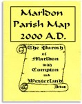
It is hoped that this will whet your appetite and encourage you to get a copy of the Map and booklet. They make ideal gifts, especially for family and friends who have perhaps moved away from Marldon. They are obtainable from Marldon Post Shop at the bargain price of only £3.95 for the Map or £4.50 for both the Map and the booklet.
Marldon Local History Group.
